Geocodes are latitude and longitude coordinates that represent a physical location. Coordinates are more precise than an address alone and are used by publishers, GPS navigation, and ride services to pin and route customers to your location.
In Yext, you can store several types of geocodes on an entity:
| Type | Description |
|---|---|
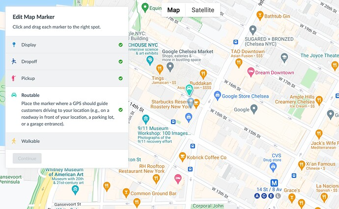
| Display | The center point of your location. Used as the primary map marker. |
| Dropoff | Where ride services or taxis should drop off visitors. |
| Pickup | Where ride services or taxis should pick up visitors. |
| Routable | Where a GPS should guide visitors with driving directions — such as a roadway entrance, parking lot, or garage. |
| Walkable | Where customers walk into your location, such as the main entrance. |
| City | Automatically set to the center point of the entity's city or region. Best used for service area businesses. |
You can use these options to correctly pin your business on the map. Pinning your location accurately with a map marker is essential so your customers know exactly how to access your business.
Set a Map Marker in Entity Edit
- Click Knowledge Graph in the navigation bar and click Entities.
- Click on the desired entity.
- Click on the Map Marker field. A map opens up.
- Click on the desired map marker and drag it to the desired position.
- (Optional) Click on the additional map markers and drag them to the desired position.
- Click Continue.
- Click Save.
Geocode Fields
The Knowledge Graph uses several fields to store and derive geocode values:
| Field | Populated By | Description |
|---|---|---|
geocodedCoordinate |
Yext system | Automatically geocoded from the entity's Address field when it is populated. |
displayCoordinate |
User | User-provided coordinates, set via the Map Marker in Entity Edit, the Entities API, or Connectors. |
yextDisplayCoordinate |
Yext system | The "best" geocode selected from the two fields above. Represents the most precise rooftop pinpoint for the location. |
Update Geocodes
Via Entity Edit
You can update any of the geocode types via the UI, by clicking into the map in Entity Edit and placing the pin for each type as mentioned in the steps above.
Via API or Connectors
Geocode values can also be set programmatically by passing coordinate values via the Entities API or a Connector. This updates the displayCoordinate field, from which yextDisplayCoordinate is then derived.